
Freedom Trail (#302)
Updated: Sep 7, 2023
Phoenix Mountain Preserve, Arizona, 2023
One word comes to mind when I think about this hike: unexpected.
It wasn't on my to-do list. When I made my initial trip to Phoenix, my list of hikes consisted of ones that I could complete with my mom, Camelback (just drop me off and pick me up), and wishlist hikes (Sedona and Tucson area). Upon arrival, I met and spoke with a lot of people who were familiar with hiking in and around the Phoenix area. The common consensus from my conversations: Camelback is overrated, crowded and there are better hikes in the area. (Obviously, there will be people who disagree with this, but that's okay, we don't have to agree on everything.) When I asked follow-up questions on what hike they would do that had similar views to Camelback, Piestewa Peak was the clear winner. Disclosure: Freedom Trail does not fully summit Piestewa Peak. See Darcy Wanders' Route for more deets.
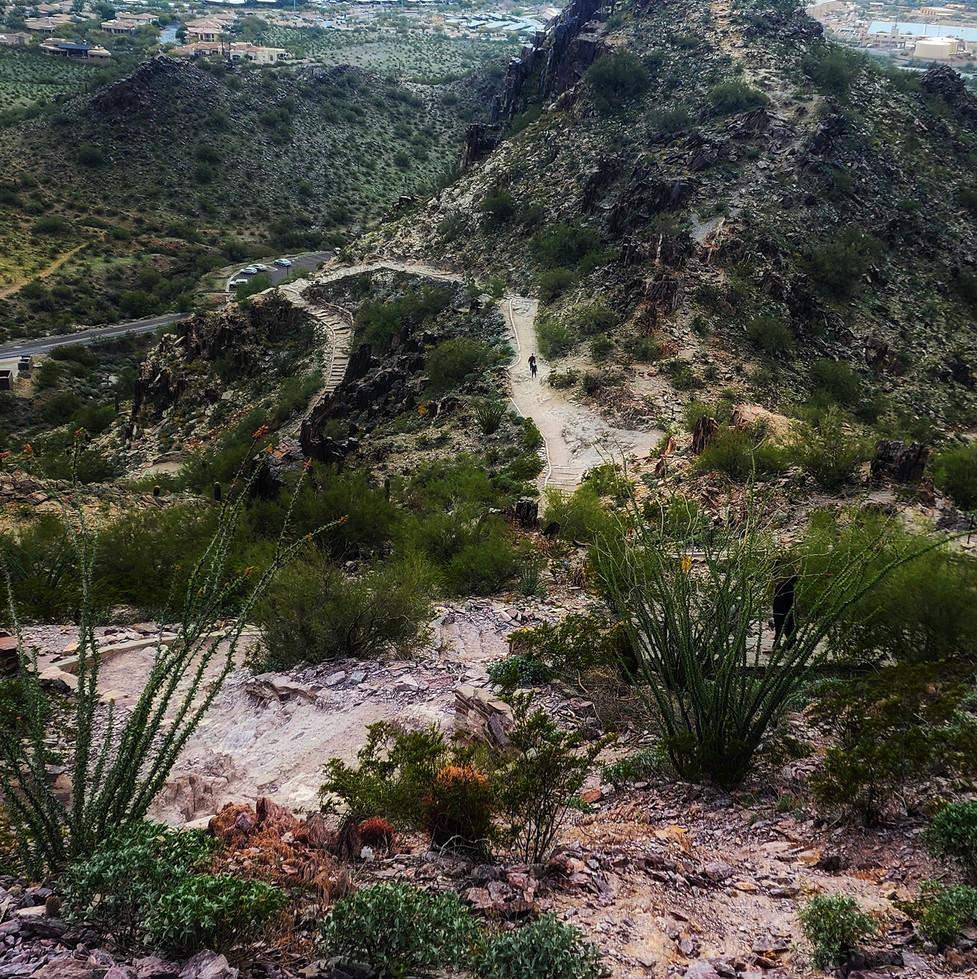
The trail maintenance and upkeep were exceptional. It was obvious that a lot of work has gone into this trail: newly constructed stairs, retaining walls to assist with trail corrosion, clear trail markings, etc. We even passed a gentleman who was on the trail picking up trash - he mentioned that Phoenix Mountain Preserve has an extensive group of volunteers who rotate walking the trails.
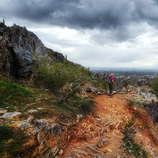
The view. Maybe I'm just partial to trails that have pizazz (alpine lakes, waterfalls, views...), but the view we got on the North end of this loop was fantastic. Maybe it was the cloud coverage and lighting? You be the judge:


TRAIL DEETS
Freedom Trail (#302) is a 3.6-mile loop that is sometimes referred to as the Piestewa Peak Circumference Trail. The trail is located in the Phoenix Mountain Preserve which boasts numerous trails ranging in difficulty. The preserve itself is located within the heart of Central Phoenix and has multiple points of entry. To access Freedom Trail, you will want to use the Piestewa Peak Park entrance. This trail and the Piestewa Peak Summit Trail (also referred to as the Summit Trail) are extremely popular, so the first parking lot (access to the Summit and Freedom Trails) fills up quickly. There are additional parking lots further up the road with access to the Freedom Trail. While the Preserve itself is pup-friendly (on leash), the Summit Trail and sections of Freedom Trail are not. The portion of Freedom Trail that is deemed "No Dogs Allowed" is clearly marked on the trail (this is the section of trail that is shared with the Summit Trail and the descent down the backside of Piestewa Peak from the Summit Trail/Freedom Trail fork).
AllTrails rates this as a hard hike and, honestly, I'm still trying to figure out how they determine trail ratings. Cue Google: "Our trails difficulty ratings are generally based on trail conditions, steepness in grades, gains and loss of elevation, and the amount and kinds of natural barriers that must be traversed." Got it.
The half-mile portion of this trail that is shared with the Summit Trail consists of rock stairs with 12" to 18" high steps. However, the rocky nature of the trail is not limited to just this section of the trail but can be found in multiple sections. Due to the popularity of these trails, the rocks are well-worn and slick in multiple spots. I could see these sections being hazardous when wet, so avoid hiking this trail if rain is in the forecast.
The overall elevation gain for Freedom Trail is 1105 feet, with a 519-foot elevation change in a half-mile (depending on your direction, this is either an increase or decrease in elevation, clockwise or counterclockwise respectively) followed by a 386-foot elevation change in the next 0.3 miles (decrease or increase in elevation, clockwise or counterclockwise respectively). The remainder of the elevation increase and decrease are spread out through the next 2.8 miles. A majority of the trail falls in the steep slope range with a few sections landing in the extremely steep slope range (31+ degrees).
So... yeah, I get the hard rating now. Peep some trail pictures taken throughout the hike below.


DARCY WANDERS' ROUTE
I downloaded the navigation for Freedom Trail (#302) from AllTrails. We decided to complete the loop counterclockwise, I wanted to go down the 519-foot elevation section versus going up (totally a personal preference). There are several trail branches on this hike with multiple access points. While there are numerous trail markers through the course of the trail, just remember that you are circling Piestewa Peak: if you are going clockwise, you'll want to stick to the right and counterclockwise to the left. The only exception to this is the Freedom Trail and Summit Trail fork, which is opposite, but clearly marked with probably the largest trail signs I have ever seen.


I want to be very clear: Freedom Trail does not reach the summit of Piestewa Peak. When we made it to the fork to head up to the summit, it had started to sprinkle and we made the decision to continue down. We did make it to the parking lot in a very light, sporadic sprinkle, but were greeted by rain on the drive home. Making decisions like this is always difficult; however, staying safe, especially in areas prone to flash floods, should always be your top priority.
Trail Popularity: The Piestewa Peak Summit Trail is extremely popular. We saw a moderate amount of trail traffic on that section of the Freedom Trail: it was a weekday, earlier afternoon, and cloudy, but still a surprising amount of people out. We had the remainder of the Freedom Trail practically to ourselves (we saw maybe 5 people).
Adding Piestewa Peak Summit Trail (#300): While we were still treated to great views on the Freedom Trail, to witness the views that rival Camelback, you will want to include the Piestewa Peak Summit Trail. This is an additional 0.6-mile, 678-foot climb to the summit from where these two trails fork. Reviews from fellow wanders indicate that this section continues to present difficult terrain and extremely steep sections. But, the overall consensus: it's worth it.
Cool AllTrails+ Feature: You can download the AllTrails map for both trails and switch between the two maps while on your hike. When you conclude your hike, your recorded route and stats will reflect both hikes combined. You're welcome. 😘
GETTING THERE
The easiest way to get to the Freedom Trail (#302) trailhead is to use the navigation system of your choice with your destination set as either the Piestewa Peak Park or Piestewa Peak Trailhead. This trail and the Summit Trail are extremely popular, so the first parking lot (access to the Summit and Freedom Trails) fills up quickly. There are additional parking lots further up the road with access to the Freedom Trail. There are vault toilets located in the parking lot along with sinks (this was a first and I loved seeing it, the water was absolutely freezing though!).
TO WANDER, OR NOT TO WANDER

If you are planning to do one hard hike while visiting Phoenix and Camelback was on your radar, then this is definitely the hike for you! Add on the Piestewa Peak Summit Trail and you will be treated to a better hike and view than Camelback*.
*according to numerous people who have completed both.
I will be back to tackle both the Piestewa Peak Summit Trail and Camelback: the ultimate "Which Hike is Better?" challenge!


MAKE IT GREAT (TIPS, TRICKS, & GEAR)
Check the Weather Forecast. This trail has a lot of sun exposure. Plan your hike according to both the hourly temperature and the UV index (low to moderate). It is recommended that you hike either early in the morning or in the evening when temperatures are lower, especially during hot summer days. Check today's weather forecast for Piestewa Peak here!
Stay Hydrated. Phoenix Mountain Preserve recommends that you bring plenty of water (one quart for short hikes; more for longer hikes). Hiking while dehydrated can lead to dizziness, muscle cramps, fatigue, confusion, and disorientation. In severe cases, it can result in heat stroke, muscle breakdown, and kidney failure. You should always bring water with you when hiking to replace the fluid that you lose from sweating. I guzzled down 3 liters of water on every Arizona hike, and was sad I ran out on a few of them.
Don't Forget Electrolytes. Electrolyte powders, tablets, and drops have exploded over the past few years, and for a good reason: if you lose a significant amount of these minerals (either by intense exercise or sweating), you'll experience dehydration. Replenishing your electrolytes during your hikes will help your body regulate and control the balance of fluids in your body and avoid dehydration. I typically begin every hike with a handheld water bottle that is full of an electrolyte mixture and either drink it during the first mile of my hike or throughout my hike (I take a swig of it during every stop). I also carry extra electrolyte tablets with me, just in case - I always know when I need another one because I get headaches. Darcy Wanders' Recommendation: I love Nuun and Liquid IV. Both are fantastic products, the biggest difference is the amount of added sugar (Liquid IV is higher, which can make them taste better). Keep plastic out of our oceans by using a reusable water bottle! Collapsible water bottles are great for any wanderer - they collapse down once they are empty to take up less space in your bag. I love this bottle by Vapur.
UPF 50+ Clothing. Wear clothing that has a high UPF rating and not just the most ultralight gear you can find. Cotton and synthetic materials do not provide adequate protection from the sun, and they offer even less UV protection when they are wet. Cotton is not your friend


Comentarios