
Saguaro, Ridge and Granite Trail Loop
- Darcy Wanders
- Apr 19, 2023
- 5 min read
Updated: Sep 7, 2023
Tonto National Forest, Arizona, 2023
Spoiler Alert: not all mountains are part of massive ranges 🤯
This might not be mind-blowing for everyone, but it was for me. I mean, I'm intimately familiar with the Colorado Rocky Mountains, the Washington Cascades, and the Washington Olympics. Even Washington's famous volcano that appears to stand alone is accompanied by fellow peaks that become visible as you get closer. Sorry if that was a spoiler for some of you... but no, Mount Rainier is not some massive volcano hanging out in the middle of sea-level plains, it's actually part of the Cascade Mountain Range. Enter: Arizona.
Arizona just takes everything I thought I knew and turns my entire world upside down. The desert can be green. Mountains don't have to be surrounded by other massive peaks. You can wrap a hot dog with bacon. Daylight savings time is ignored. Arizona does what it wants.
When we were on our way to our first hike (Butcher Jones) we passed a lone red mountain and I was instantly obsessed. Upon further research, I learned that the mountain's name is Mount McDowell, but commonly called Red Mountain, and hot damn, I was pumped to explore that mountain! I also learned that it is located on the Salt River Pima-Maricopa Indian Reservation, and has been off-limits to non-tribe members since the early 1980s due to vandalism (come on people, let's do better).
I realized that my chances of meeting a tribe member, befriending them, and convincing them to take me on a hike were less than 0.001%. So, I did the next best thing: I went for a hike on the opposite side of the Salt River!

TRAIL DEETS
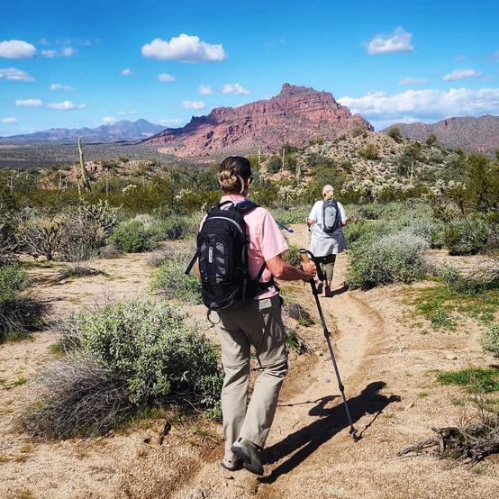
Saguaro, Ridge and Granite Trail Loop is a 3.9-mile loop located within Tonto National Forest. AllTrails rates this as a moderate hike with an overall elevation gain of 521 feet and a max elevation of 1,766 feet. It is part of the Hawes Trail System, which began as a web of unauthorized social trails developed over the years by local mountain bikers and hikers. The system is pup-friendly (on leash) and does not offer any amenities (no toilets).
The trail system is maintained by the Hawes Trail Alliance, a non-profit organization in Mesa, Arizona. You can find more details on the alliance, including how to donate and their trail etiquette, here.
DARCY WANDERS' ROUTE
I downloaded the navigation for Saguaro, Ridge and Granite Trail Loop from AllTrails. We completed the loop counterclockwise, allowing us to complete the elevation gain spread out through 2.9 miles. The trail was well maintained and did have a few technical sections (rocky terrain and larger steps). Looking for more of a challenge: complete the loop in the opposite direction (clockwise) and climb the 521 feet throughout the first mile.
This is a massive trail system, with multiple branches/intersections. While there are trail markers, we still got lost: we missed the turn-off from Ridge Trail onto Saguaro Trail. Fortunately, we were able to navigate back to the correct trail using AllTrails and The Cut Trail. If you do get lost, please make sure to use your navigation and existing trails.
With the addition of our "detour," we completed 4.37 miles and 633 feet in elevation gain.


Trail Popularity: The Hawes Trail System is a very popular area for hiking and mountain biking, so you will likely see other people on the trail. We went in the middle of the afternoon on a weekday and encountered about a dozen people, a majority of them on bikes.
Who Yields to Who:
Bikers Yield to Hikers and Horses
Hikers Yield to Horses
Horses Yield to Nobody
GETTING THERE
The easiest way to get to the Saguaro, Ridge and Granite Trail Loop trailhead is to use the navigation system of your choice with your destination set as Maricopa Trail to Hawes Trails Parking. Parking is located off of the shoulder of the North Bush Highway and is pretty limited with zero amenities (no toilets). Tonto National Forest is currently addressing parking issues with the recent approval of two new parking lots. At the time of publication, parking is free; however, depending on what amenities are approved within the parking lot, the area could become a fee area where a Tonto Pass is required.
TO WANDER, OR NOT TO WANDER

Beautiful hike through the Sonoran Desert with incredible views (including Red Mountain) and close to Mesa - who could ask for more?! Plan your trip during a weekday when the desert is in bloom and you'll definitely have an amazing experience! BONUS: Continue driving north on the N Bush Highway and look for the Salt River Wild Horses!


MAKE IT GREAT (TIPS, TRICKS, & GEAR)
Check the Weather Forecast. This trail has a lot of sun exposure. Plan your hike according to both the hourly temperature and the UV index (low to moderate). You should hike either early in the morning or in the evening when temperatures are lower, especially during hot summer days. Check today's weather forecast for Hawes Trail System here!
Stay Hydrated. Bring plenty of water (one quart for short hikes; more for longer hikes). Hiking while dehydrated can lead to dizziness, muscle cramps, fatigue, confusion, and disorientation. In severe cases, it can result in heat stroke, muscle breakdown, and kidney failure. You should always bring water with you when hiking to replace the fluid that you lose from sweating. I guzzled down 3 liters of water on every Arizona hike, and was sad I ran out on a few of them.
Don't Forget Electrolytes. Electrolyte powders, tablets, and drops have exploded over the past few years, and for a good reason: if you lose a significant amount of these minerals (either by intense exercise or sweating), you'll experience dehydration. Replenishing your electrolytes during your hikes will help your body regulate and control the balance of fluids in your body and avoid dehydration. I typically begin every hike with a handheld water bottle that is full of an electrolyte mixture and either drink it during the first mile of my hike or throughout my hike (I take a swig of it during every stop). I also carry extra electrolyte tablets with me, just in case - I always know when I need another one because I get headaches. Darcy Wanders' Recommendation: I love Nuun and Liquid IV. Both are fantastic products, the biggest difference is the amount of added sugar (Liquid IV is higher, which can make them taste better). Keep plastic out of our oceans by using a reusable water bottle! Collapsible water bottles are great for any wanderer - they collapse down once they are empty to take up less space in your bag. I love this bottle by Vapur.
UPF 50+ Clothing. Wear clothing that has a high UPF rating and not just the most ultralight gear you can find. Cotton and synthetic materials do not provide adequate protection from the sun, and they offer even less UV protection when they are wet. Cotton is not your friend.


Commentaires